Emerging in the 1990s, the notions of geoheritage and geodiversity have been receiving growing attention from academic communities, international organizations and public authorities. The concept of geoheritage notably incorporates the idea that certain geological sites represent precious windows onto past natural events and the way the planet works. As such they need to be protected and promoted in the same way as historical heritage sites are. As for the concept of geodiversity, it is based on a parallel between the variety of geological objects and that of living beings. The idea is thus to implement identification and conservation initiatives comparable to those used for biodiversity.
It was in this context that, in 2020, IFPEN signed a partnership agreement with UNESCO, one of the objectives of which is to share digital tools facilitating the promotion of geoheritage and geodiversity to the general public[1]. These tools are constructed in synergy with the R&D initiatives conducted for industry, revisiting underlying technologies as part of a society-focused approach.
One example is the use of virtual reality enabling people to visit geological outcropsa. This research is hinged around DOM (Digital Outcrop Models) methodology: from a series of photos acquired using the principles of photogrammetryb, it is possible to produce a virtual 3D geometric representation of an outcrop, with its original texture and colors. Initially developed to meet the needs of the oil industry[2] and increasingly used in the teaching of “Earth Sciences”, DOM methodology is also ideal for disseminating knowledge related to geoheritage to the general public, enabling people to discover sites without having to actually travel to them.
IFPEN’s researchers took advantage of the increasing accessibility to immersive technologies in 2020 within the framework of a partnership with an SME. The result was a demonstrator integrating a DOM model in a virtual immersive environment, focusing on the Annot sandstone formation, a reference site for the understanding of deep-water sedimentary systems (figure 1). Non-expert users can interactively learn about the geology of the outcrop and access educational content (texts, photos, videos) directly integrated in the visualization of the natural site.
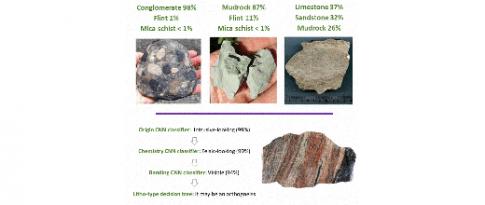
A second example is the use of artificial intelligence to raise public awareness of geodiversity. IFPEN’s researchers trained a deep learning model to recognize different types of rocks from photos of samples. This model was then integrated into a mobile application enabling non-experts to derive information from photographs of the rocks around them about their nature, their characteristics and their different uses (figure 2). Currently at the prototype stage, this application, called RockNetTM, is designed to promote a citizen science type approach. Accordingly, all of the photos taken by users will be used to build a common atlas and a database, thereby gradually improving the accuracy and quality of the results provided[3].
Both these examples illustrate how digital technology can potentially help promote geological knowledge to the general public[4], one of the keys to ensuring more and more citizens become active players in debates about the protection of the environment, the sustainable use of resources and the evolution of the planet.
Click on pictures to enlarge
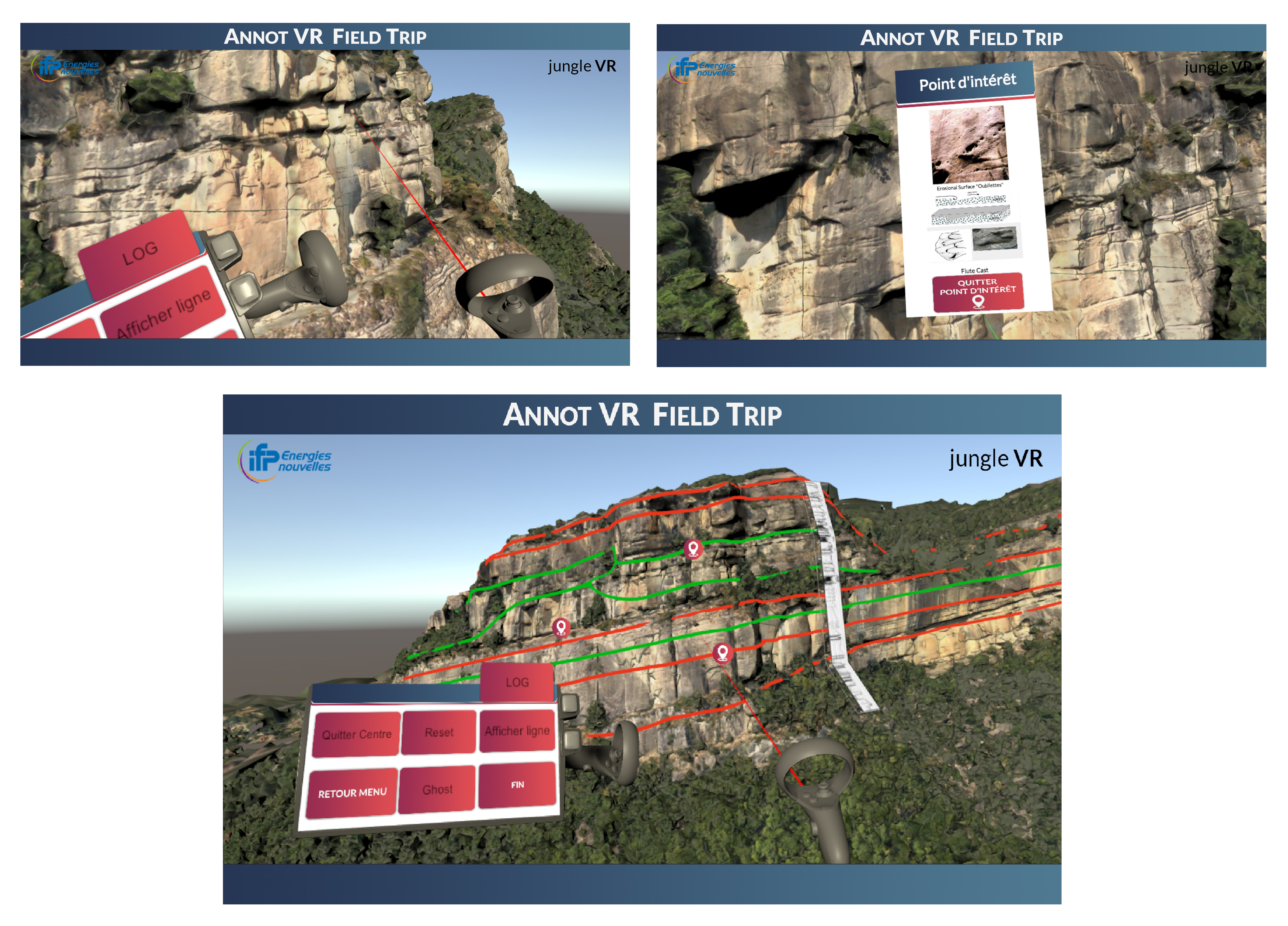
In addition to being able to view the outcrop from various angles and zoom in and out, users can interact with the geological data and accompanying educational content (stratigraphic interpretations, sedimentary logs, sample photos, texts and videos, etc.).
>> More images of the technology in the following video clip: https://www.youtube.com/watch?v=QOPX0wvwUE0.
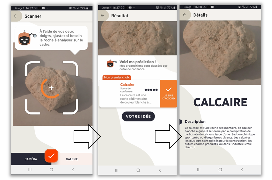
From a photo taken by the user with their smartphone, the artificial intelligence model identifies the corresponding rock type and provides the public with some basic information. More details on www.rocknet.fr (in French).
a- Exposed solid rock formations, often dozens of meters long, directly visible on the Earth’s surface. They are extremely useful for geologists because they offer a direct picture of the nature of the underground environment.
b- Technique used to reproduce a scene in 3D from images acquired from different angles and viewpoints.
Publications:
[1] “IFPEN and UNESCO join forces in the field of geoscience” press release, 6 October 2020.
[2] Deschamps R., Joseph P., Lerat O., Schmitz J., Doligez B. et Jardin A. (2015). AAPG Search and Discovery, Art. no 41696. http://www.searchanddiscovery.com/documents/2015/41696deschamps/ndx_deschamps.pdf.
[3] Bouziat A., Desroziers S., Feraille, M., Lecomte J.-C., Cornet C., Cokelaer F. et Divies R. (2021). EGU General Assembly 2021, online, 19–30 April 2021, EGU21-13068. https://doi.org/10.5194/egusphere-egu21-13068.
[4] Bouziat A., Schmitz J., Deschamps R. et Labat K. (2020). European Geologist, 50. http://doi.org/10.5281/zenodo.4311379.
Scientific contact: antoine.bouziat@ifpen.fr
You may also be interested in
Artificial Intelligence-assisted interpretation of geological images
Over the last decade, deep learning applied to image analysis has rapidly developed in scope to cover numerous fields. However, its potential remains underexploited in geology, despite the fact that it is a discipline that relies to a large extent on visual interpretation. To contribute to the digital transformation of industries related to the underground environment, researchers at IFPEN have implemented deep learning in three “profession-specific contexts”, each involving different types of geological images.