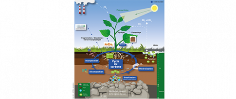
Peatlands only occupy 3% of the earth’s surface but contain more than 25% of the organic carbon stored in the surface layers of the subsoil. Plant matter accumulates slowly there and undergoes a slow decomposition process under the effect of a water-saturated, oxygen-poor environment. Therefore the peat can still decompose and is particularly vulnerable to environmental changes. Hence, the exposure of these organic carbon stores to the effects of climate change (increase in temperatures, drought, fires) and human activities (drainage and destruction of wet zones) can lead to the release of significant quantities of greenhouse gases.
In order to better understand and characterize these carbon storage/release phenomena, an international team recently turned their attention to the “Cuvette Centrale” peatlands of the Central Congo Basin1 (figure 1.a). Researchers from CEREGE (European Center for Research and Education in Environmental Geosciences) and MARUM (Center for Marine Environmental Sciences) successfully reproduced the evolution of the regional environment and climate over the course of the past 22,000 years by studying biomarkers (figure 1.b).
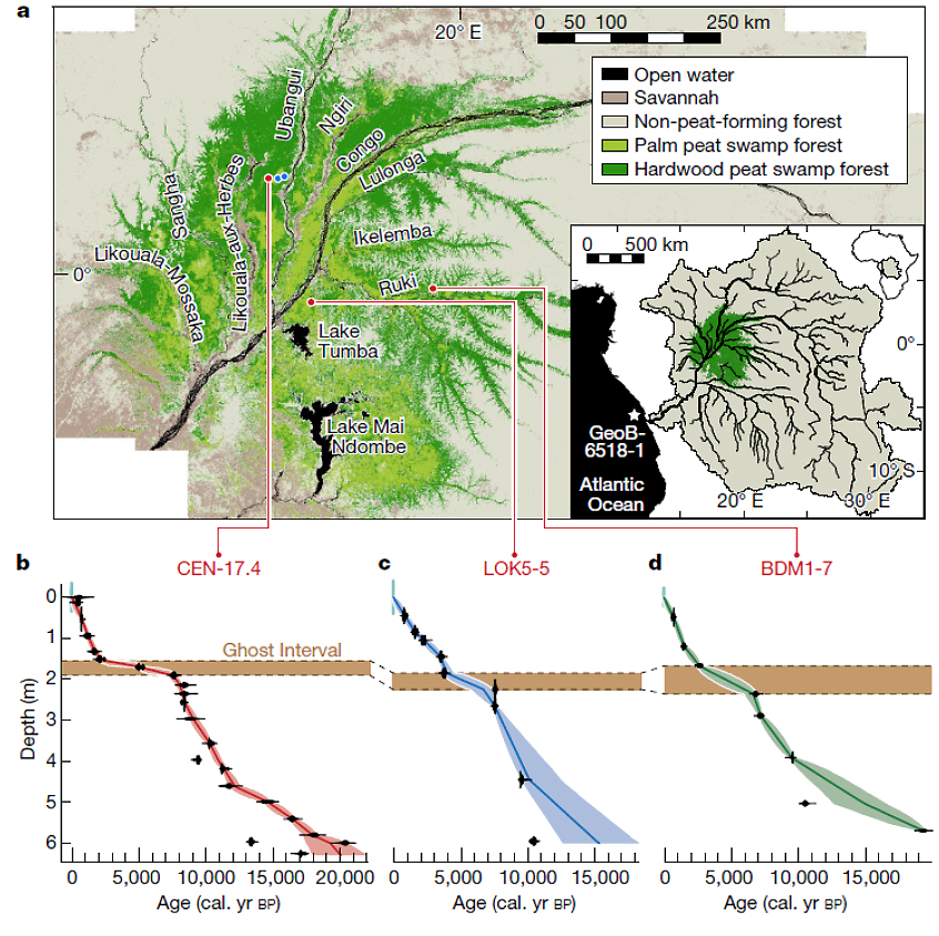
a) Map of the Cuvette Centrale showing the spatial distribution of the swamp forests and the location of peat cores;
b) Radiocarbon dating of the peat cores studied.
The break in the modeled age-depth profiles, highlighted by a horizontal brown band, indicates the “Ghost Interval” of very little peat build up. The dotted lines show the stratigraphic correlations.
In addition, researchers from IFPEN, UNIL2 and the British Geological Survey measured the degree of peat decomposition using Rock-Eval® analyses. The global study, published in Nature [1], showed that between 5,000 and 2,000 years BP, the region experienced a drought responsible for the decomposition of several meters of peat, which necessarily led to the emission of considerable quantities of greenhouse gases.
While the hydroclimatic conditions enabling the formation of peat gradually became re-established around 2,000 years ago, this study showed that this peat remained extremely vulnerable to hydroclimatic changes. Such changes, like a variation in rainfall and/or seasonality, may once again cause the release of a quantity of carbon dioxide equivalent to three years of global emissions currently.
In order to avoid the flow of greenhouse gases into the atmosphere, under the effect of a further degradation of this peat, it is necessary to have access to tools to predict the effect of these environmental changes (climate, impact of human activities) on the regional water balance. Topogenic peatlands3, like those studied, are primarily controlled by the quantity and distribution of rainfall in the catchment area. In order to understand their formation and dynamics over time, it is necessary to describe hydrologic changes on the surface and in the groundwater of the catchment area.
To do so, hydrological and stratigraphic modeling was conducted within the context of the VULCARFATE project [2, 3]. From the map showing the Congo’s topography (figure 2a) and climate data, surface and subsurface water flows (figure 2b) were determined using DionisosFlow® software. This modeling was then combined with sediment transport laws in order to determine the location of certain sedimentary environments (figure 2c).
Concerning peatlands, we thus have a tool that can be used to anticipate the effect of climate change and human activities on their carbon stocks, which could then be used as a basis for better managing their vulnerability.
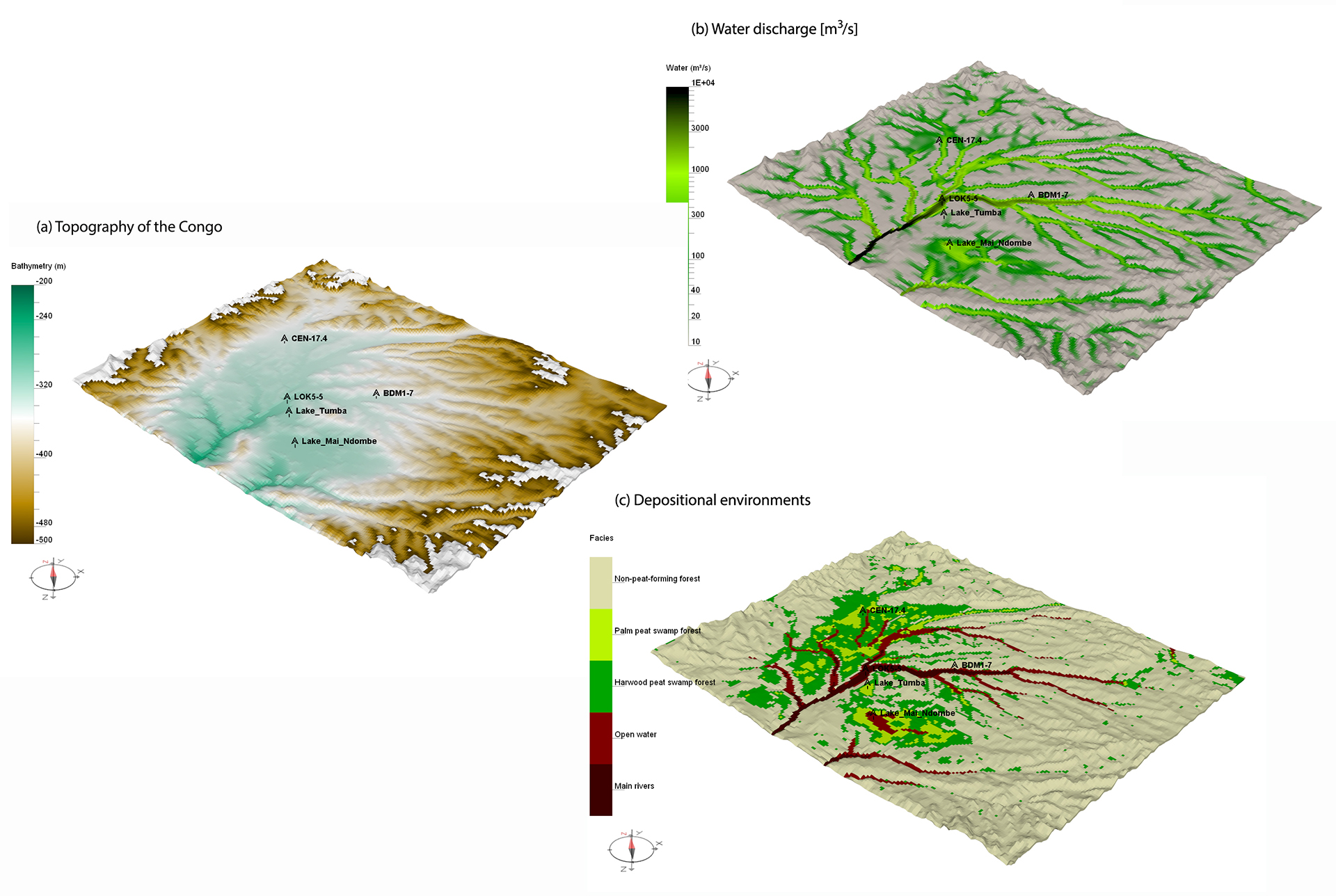
a) map of current topography;
b) simulation of surface water flow;
c) simulation of the distribution of different types of swamp forests and peat.
1- Extending over 16.7 million hectares and representing 28% of the carbon of tropical peatlands.
2- Lausanne University.
3- Peatland in which water is trapped in depressions, called “cuvettes”.
References:
-
Garcin, Y., Schefuß, E., Dargie, G.C., Hawthorne, D., Lawson, I.T., Sebag, D. et al. Hydroclimatic vulnerability of peat carbon in the central Congo Basin. Nature 612, 277–282 (2022).
>> https://doi.org/10.1038/s41586-022-05389-3
-
Chauveau, B., Granjeon, D., Sebag, D., Bemer, E., Frappart, F., Braun, J-J., Bogning, S. Le bassin de l'Ogooué : Devenir des sols et du carbone associé sous contraintes climatiques et anthropiques. Continental Surface Modeling Days event, Grenoble, 6-7 October 2022..
-
Impact des changements globaux sur les réservoirs vulnérables de carbone : piégeage et émissions de carbone dans les sols et les eaux de l'Arctique à l'Equateur : [Global change impact on vulnerable carbon reservoirs: carbon sequestration and emissions in soils and waters from the Arctic to the Equator]: interdisciplinary project, coordinated by the IRD (French Research Institute for Development) and bringing together partners from six countries (France, USA, Russia, Gabon, Spain and Switzerland).
>> https://vulcar-fate.obs-mip.fr/en/homepage
Scientific Contacts: david.sebag@ifpen.fr ; Didier Granjeon ; elisabeth.bemer@ifpen.fr
You may also be interested in
Rock-Eval®: supporting soil research for the climate challenge
One way to decrease the amount of atmospheric CO2 is to reduce greenhouse gas emissions of fossil origin, but it is also possible to increase the quantities of carbon stored in the soil. (...) In the current context of climate change, understanding the evolution of carbon in the ground is critically important. It is for this reason that IFPEN wanted to study the potential offered by Rock-Eval®, a flagship of oil research...
Natural gas in marine sediments: a climate issue?
Just like carbon dioxide (CO2), but with a much higher GWPa, methane CH4) is a gas which, according to the IEAb, is responsible for around 30% of the increase in global temperatures since the industrial revolution...