


Coastal sedimentary basins evolve under the effect of interactions between, on the one hand, hydroclimatic processes taking place in catchment areas, and on the other hand coastal marine processes that remodel the coastline. The evolution of these environments is naturally controlled by the climate, over different time periods (ranging from tens of years to thousands of years), through variations in sedimentary flows and erosion, which alter the terrain. Another more recent factor controlling geomorphological evolution which has an extremely significant impact is human activity. Anthropism has considerably modified the natural environment impacting resource management (aquifers) and regional planning (river bank instability, flood management, etc.).
In order to predict the impact of various environmental changes scenarii, and thus enable the planification of appropriate local policies, it is essential to have access to modeling tools capable of integrating these different aspects. This requires the development of numerical models that enable to integrate the factors driving changes in the natural environment. Such models must then be parametrized, and the main challenge here is to quantify the different controlling factors and their impacts on the environment over various periods of time.
The Rhône delta, and more particularly its evolution since the quaternary glaciation period, is the ideal laboratory for studying human/habitat interactions and their impacts on the environment. The stratigraphic evolution of the Rhône delta is extremely well documented through numerous sedimentary archives accessible both on the delta plain and in the marine area of the delta, as well as in the catchment area. Moreover, the numerical interpretation of old maps [1-3] and satellite data enable to unravel the evolution of land use, which can then be used as a basis for determining erosion potential and particle flows transported to the delta. The analysis of all this data (figure) will help at calibrating stratigraphic models of the delta’s past evolution, using DionisosFlowTM software. On this basis, it will be possible to propose predictive scenarii for the delta system evolution.
This approach, aiming at correlating the evolution of the Rhône catchment area with the delta’s sedimentary dynamic is being implemented within the framework of a PhD thesisa in partnership with Lumière Lyon 2 University and the Rhône Sediments Observatory (OSR).
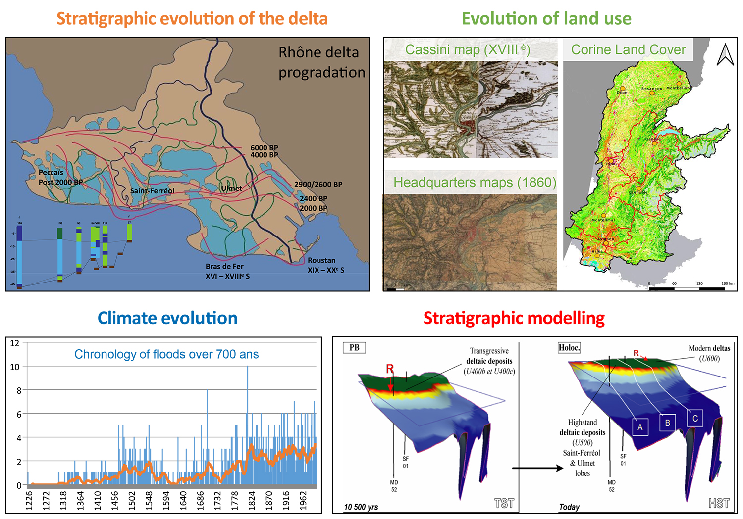
2- volumes of sediments eroded in the catchment area (indirectly quantified based on the evolution of land use),
3- climatic evolution, in order to
4- calibrate a stratigraphic modeling approach.
a- Thesis title: “Impact of hydroclimatic and anthropological parameters on sedimentary dynamics. Rhône delta system in the Holocene-Anthropocene transition”.
References:
- Martinez, T., Hammoumi, A., Ducret, G., Moreau, M., Berger, J.F., Deschamps, R., 2022. Semantic multi-class segmentation of the Cassini land use map (XVIIIth c.): the first step of a geomorphological comparative studies. Article submitted to Computer geosciences
- Martinez, T., Deschamps, R., Ducret, G., Berger, J.F., Hammoumi, A., Moreau, M., Jouet, G., Piégay, H., Vella, C., 2022. Fluvial geomorphology, sedimentology and cartography supporting spatio-temporal modelling of the large Rhodanian catchment area. Paper presented at the Quaternaire 13 conference, Strasbourg 14-18 March 2022
- Martinez, T., Hammoumi, A., Ducret, G., Moreau, M., Berger, J.F., Deschamps, R., 2022. Inputs and application of an automated multi-class segmentation of the Cassini land use map (XVIIIth c.) to the understanding of landscape and river dynamics at the end of the LIA. Extended abstract at IS Rivers congress, Lyon 4-8 July 2022
Scientific contact: remy.deschamps@ifpen.fr
You may also be interested in
Global change, impact on landscapes and water resources
Today, the impact of climate change and human activities on the evolution of landscapes and water resources is a major challenge. Predicting it requires dedicated tools capable of evaluating, 100 years ahead, the consequences of different scenarios on watersheds and groundwater. To this end, IFPEN is developing modeling approaches targeting erosion-transport-deposition phenomena combined with surface and subsurface flows. ...
Underground modeling: an essential step for the energy transition
To address the challenges of the energy transition, the subsurface has an important role to play, both in terms of providing resources and offering storage solutions. (...) Numerical models can help gain a better understanding of the subsurface with a view to its long-term management and optimal use. Developed for a number of years now at IFPEN, initially for the petroleum industry, such models cover scales ranging from the sedimentary basin to the reservoir...
Geoheritage and geodiversity accessible to all thanks to digital technology
Emerging in the 1990s, the notions of geoheritage and geodiversity have been receiving growing attention from academic communities, international organizations and public authorities. (...) It was in this context that, in 2020, IFPEN signed a partnership agreement with UNESCO, one of the objectives of which is to share digital tools facilitating the promotion of geoheritage and geodiversity to the general public...